Most of Neshoba under rare 'Extreme Threat' for snow, ice
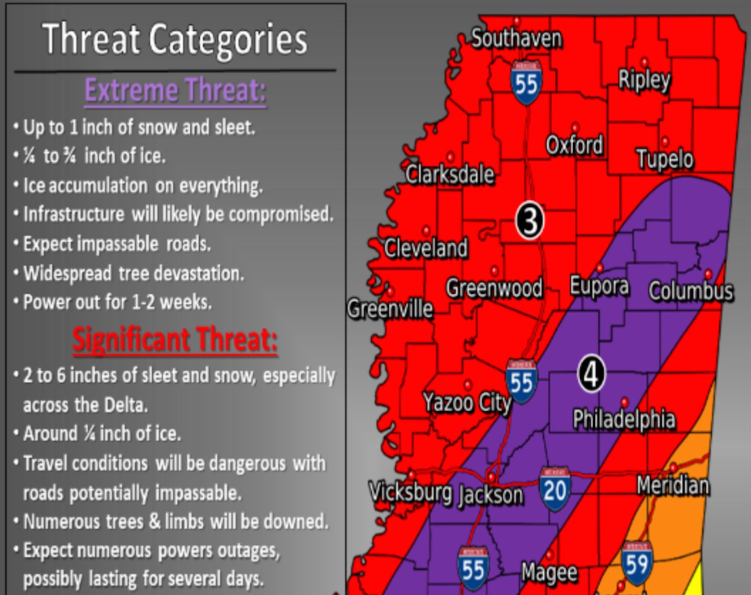
Snow accumulations of up to six inches and ice accumulations up to one-half-inch are possible in parts of Neshoba County before Tuesday, officials said Sunday afternoon as a winter storm warning remains in effect.
The heaviest amounts of precipitation will be from Monday around 3 a.m. to noon, officials said following a 2 p.m. briefing on Sunday.
Most of Neshoba County, including the city of Philadelphia, has been placed under an “Extreme Threat” category very seldom used by the National Weather Service, officials said.
Monday afternoon and Monday night wind chills could reach 0-15 degrees, according to officials.
Philadelphia, Neshoba Central and Leake Academy will all be closed on Monday. Leake will be closed Tuesday as well.
Choctaw Tribal School had not made an announcement by 6 p.m. but had said they are monitoring the situation. Union had not made a formal announcement either.
East Central Community College will be closed Monday and Tuesday but using virtual learning.
WHAT...Heavy mixed wintry precipitation is expected. Total snow and sleet accumulations of up to 6 inches and ice accumulations of one quarter to three quarters of an inch are possible.
WHERE...Portions of northeast Louisiana, southeast Arkansas, and central, east-central, north-central, northeast, northwest, south-central, southwest and west-central Mississippi.
WHEN...Until 6 AM CST Tuesday.
IMPACTS...Power outages and tree damage are likely due to the ice. Travel could be nearly impossible. The hazardous conditions could impact the morning and evening commute times. Very cold wind chills as low as 5 degrees below zero could result in hypothermia if precautions are not taken.
ADDITIONAL DETAILS...The first round of light freezing rain, mixed with light sleet and light snow was moving over northeast Mississippi late this afternoon. The ice accumulations are expected to continue causing impacts to portions of the area this evening before a more widespread round of heavier freezing rain, sleet, and snow develops later tonight and spreads across the area through the day on Monday.
PRECAUTIONARY/PREPAREDNESS ACTIONS
If you must travel, keep an extra flashlight, food, and water in your vehicle in case of an emergency.
The latest road conditions for Mississippi can be obtained by visiting mdottraffic.com.